

Floodplain Management
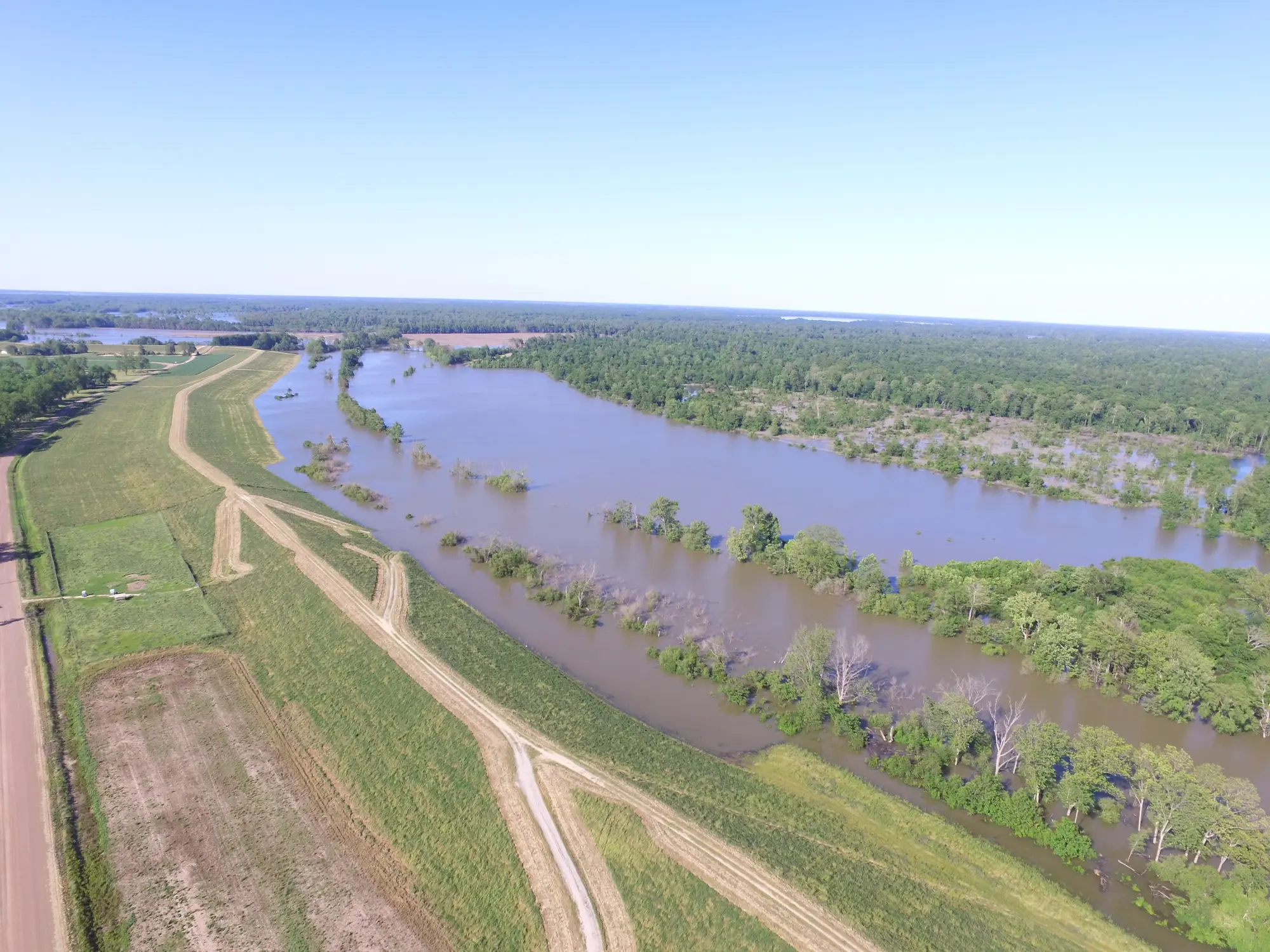
The east bank of Ascension Parish has a history of extensive flooding. Most flood problems stem from the Parish's low topographic relief. Streams draining East Ascension typically originate near the east bank levee of the Mississippi River at an elevation of approximately 20 feet. These streams flow easterly and southeasterly and enter swamplands at an elevation of approximately 3.5 feet to 4.0 feet. Most of these streams have formed natural levees along each bank throughout most of their lengths. The natural levees in some locations are the highest ground between the principal streams. Because of low relief in these areas, there is flooding along the lower reaches of all or most of these streams.
The past history of flooding along streams indicates that flooding may occur during any season of the year. A majority of the major floods have occurred during February, April, August and November. These floods are normally the result of spring rains, thunderstorms and/or hurricanes. Floods occurring during all months, or more specifically during late summer, are often associated with the heavy rains accompanying hurricanes moving northward from the Gulf of Mexico. Flood problems in Ascension Parish stem from low relief that is characteristic of much of the Mississippi River alluvial valley. Major flooding has occurred in the City of Gonzales in 1926, 1961, 1966, 1977, 1983, 1989, 1991, 1995, and 2001.
Flooding in Ascension Parish is also caused by headwater overflow of the Amite River, New River, Black Bayou, Bayou Narcisse, Bayou Francois, and Bayou Conway. Backwater flooding occurs along the lower reaches of these streams and along Bayou Manchac. Backwater flooding is particularly severe when the Amite River is above flood stage.
The USGS, in cooperation with the Louisiana Department of Transportation and Development, Louisiana Office of Homeland Security & Emergency Preparedness, East Baton Rouge Parish, Amite River Basin Drainage and Water Conservation District, National Weather Service, and U.S. Army Corps of Engineers, operates a Flood Warning System in the Amite River Basin. This system is a network on nine automated river stage stations that transmit information through radio telemetry to the USGS Hydrowatch Operations Center in Baton Rouge. During floods, the public and emergency response agencies use this information to make decisions about road closures, evacuations, and other public safety issues. During a flood, the USGS provides current river stage information to the public through news releases, and more directly through a “Home Page” on the internet at www.usgs.gov.
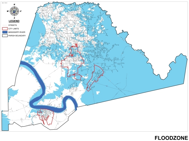
Generally speaking, all homes are at risk of being flooded. However, some areas due to low elevation, topography, and proximity to bodies of water are at a much higher risk. The Federal Emergency Management Agency (FEMA), through its National Flood Insurance Program has developed Flood Insurance Rate Maps (FIRMs) for communities that participate in the Program. FIRMs are designed to assess flood risks for insurance purposes. These maps denote “flood zones” which are geographical areas that historically have flooded. Every homeowner should be aware of the flood zone where their home is located . The local permitting office can help determine the flood zone where a property is located. Your FIRM can be viewed at the Ascension Parish Library, on our Online Maps Gallery, or at your Building Permit Office depending on the community where you live. For copies of elevation certificates, call your permitting office.
Rather than wait for a flood to occur, you can act now to protect your property from flood damage. The first thing is to know your flood hazard risk. Check with your public works office to find out the following:
- How high would the 100-year flood be on your building?
- How much warning time can you expect?
- How will you get the flood warning?
- Will your access or evacuation route be blocked by flooded streets?
Ask your local permitting office for a free copy of Repairing your Flooded Home, FEMA-234. Next, talk to the Floodplain Administrator Office about protecting your property. Describe your lot and your building. They may recommend that you look into re-grading your lot or retrofitting your building. “Retrofitting” means altering your building to eliminate or reduce flood damage.
Retrofitting measures include:
- Elevating the building so that flood waters do not enter or reach any critical portions of it,
- Constructing barriers out of fill concrete between the building and flood waters,
- “Dry floodproofing” to make the building walls and floor watertight so water does not enter,
- “Wet floodproofing” to modify the structure and relocate the contents so that when flood waters enter the building there is little or no damage,
There are several good references on retrofitting in the Ascension Parish Public Library. Many of these will inform you about retrofitting techniques and help you decide which might best for you.
If you have a flooding, drainage or sewer problem, please contact the Citizen Service Center (225) 450-1200 or email them at 311@apgov.us for assistance.
Basic homeowner’s insurance policies don’t cover damage from floods. However, because Ascension Parish participates in the National Flood Insurance Program, federally subsidized flood insurance is available to everyone in the Parish. The National Flood Insurance Program is a government subsidized program and the Federal government writes the policy and sets the rates. Flood Insurance is available on buildings and personal property (the contents of your home or business). The cost of the policy depends on your flood zone, elevation, and age of your home. A preferred risk policy is available to people located in zone X-shaded, which is not a high risk flood zone. Renters living in a flood zone can also protect their possessions with flood insurance. Remember, there is a 30 day waiting period before a policy becomes effective.
If you are already covered by flood insurance, there are a few things of which you should be aware. Some people have purchased flood insurance because it was required by their bank when they obtained a mortgage or home improvement loan. Usually, these policies just cover the building’s structure and not the contents. During the kind of flooding that happens in Ascension Parish, there is usually damage to the furniture and contents in addition to the structure. Also, remember that your policy must be renewed each year.
Mandatory Purchase Requirement: The mandatory purchase requirement applies to all forms of federal or federally related financial assistance for buildings located in a Special Flood Hazard Area (SFHA). This requirement affects loans and grants for the purchase, construction, repair, or improvement of any publicly or privately owned building in the SFHA, including machinery, equipment, fixtures, and furnishings contained in such buildings. Financial assistance programs affected include loans and grants from agencies such as the Department of Veterans Affairs, Farmers Home Administration, Federal Housing Administration, Small Business Administration, and the Federal Emergency Management Agency. The requirement also applies to secured mortgage loans from financial institutions, such as commercial lenders, savings and loan associations, savings banks, and credit unions that are regulated, supervised, or insured by federal agencies such as the Federal Deposit Insurance Corporation and the Office of Thrift Supervision. It also applies to all mortgage loans purchased by Fannie Mae or Freddie Mac in the secondary mortgage market.
If the building is in a SFHA, the agency or lender is required by law to require the recipient to purchase a flood insurance policy on the building. The requirement is for structural coverage equal to the amount of the loan (or other financial assistance) or the maximum amount available, whichever is less. The maximum amount for a single-family house is $250,000.
The mandatory purchase requirement does not affect loans or financial assistance for items that are not covered by a flood insurance policy, such as vehicles, business expenses, landscaping, and vacant lots. It does not affect loans for buildings that are not in the SFHA, even though a portion of the lot may be flood prone. While not mandated by law, a lender may require a flood insurance policy for a property in any zone on a Flood Insurance Rate Map.
Also, check to make sure the community number on your policy is correct. If you are within the city limits of any of the following municipalities, use the corresponding community number as shown below.
Donaldsonville - 220014
Gonzales - 220015
Sorrento - 220016
Unincorporated Areas - 220013
For more information, use the following links.
Clean everything that got wet. Flood water may have picked up sewage and chemicals from roads, farms, factories, and storage buildings. Spoiled flood, flooded cosmetics, and medicine can all be health hazards. When in doubt, throw them out.
Do not walk through flowing water. Drowning is the number one cause of flood related deaths. Currents can be deceptive; six inches of moving water can knock you off of your feet. Use a pole or stick to ensure that the ground is still there before you go through an area where the water is not flowing.
Carbon monoxide exhaust kills. Use a generator or other gasoline-powered machine outdoors. The same goes for camping stoves. Charcoal fumes are especially deadly. Cook with charcoal outdoors.
Do not drive through a flooded area. More people drown in their cars than anywhere else. Don’t drive around road barriers; the road or bridge may be washed out.
Be alert for gas leaks. Use a flashlight to inspect for damage. Don’t smoke or use candles, lanterns, or open flames unless you know the gas has been turned off and the area has been ventilated.
Stay away from power lines and electrical wires. The number two flood related killer after drowning is electrocution. Electrical current can travel through water. Report downed power lines to the power company or the Ascension Parish Office of Homeland Security and Emergency Preparedness.
Look before you step. After a flood, the ground and floors are covered with debris including broken bottles and nails. Floors and stairs that have been covered with mud can be very slippery.
Have your electricity turned off by the power company. Some appliances such as television sets, keep electrical charges even after they have been unplugged. Do not use appliances or motors that have gotten wet unless they have been taken apart, cleaned, and dried.
Look out for animals, especially snakes. Small animals that have been flooded out of their homes may seek shelter in yours. Use a pole or stick to poke and turn things over and scare away small animals.
It is illegal in Ascension Parish to dump any type of debris into a canal or drainage ditch. This debris can become entangled in culverts and shallow streambeds and reduce drainage capacity causing the water to back up. Debris dumping in canals or drainage ditches should be reported to the local public works department or local law enforcement agencies. You should also keep drainage ditches on your property free of debris, foliage, and vegetation that would impede the flow of water.
You should also check with the local permitting department before you build on, alter, re-grade, or fill on your property. A permit may be needed to ensure that projects do not cause flooding problems on other properties. If you see a building being constructed within the Parish without a building permit posted, contact the appropriate phone numbers listed below.
External Flood Resources
Answers to many common questions, how to reduce risk, protect your home and other structures.
Ascension Parish FlRM Maps
Explore all Ascension Parish flood maps.
Repairing Your Flood Damaged Homes
Please read the documents linked below if you are repairing your home due to any recent flood damage.
History of Floodplain Management in Ascension Parish 2026
Wetland Determination Form
Learn how to request a wetland determination.
